A realm of stone and salt spanning 200,000 square kilometers, the Ustyurt Plateau is a magnet for nature enthusiasts and seekers of the unknown. This rocky expanse, where the borders of Kazakhstan, Turkmenistan, and Uzbekistan converge, formed 20 million years ago yet remains shrouded in mystery. Beyond the reach of scientific expeditions, intrepid travelers venture here to marvel at chalky peaks, deep ravines, and sheer cliffs within this clay-gravel desert.

For millennia, the Ustyurt Plateau lay undiscovered. Its exploration began in the 19th century, when an accidental find revealed a vast, flat highland with an otherworldly landscape and steep escarpments rising 350 meters high.
The plateau’s first recorded exploration came in 1825, led by Eduard Aleksandrovich Eversmann, a naturalist who joined Fyodor Fyodorovich Berg’s Aral-Caspian topographic expedition. Moving eastward from the Ural River along the Caspian Sea, the team anticipated encountering the “Misty Mountains.” Instead, they discovered an expanse that appeared to be the exposed floor of a primordial sea. Cracked salt flats, towering escarpments, and windswept plains painted a surreal landscape—akin to the seabed or even the surface of an alien planet. Scientists remain captivated by the geological and historical riddles this plateau poses.
A Marine Legacy
Eons ago, Ustyurt was submerged under the ancient Tethys Ocean, a precursor to today’s Mediterranean and Black Seas. Evidence of its aquatic past abounds—shells, marine fossils, and ammonites dot the plateau, while valleys are carved with grottoes, and salt lakes lie nestled in depressions.
The Tethys, alternately referred to as an ocean or sea, spanned the vast chasm between Earth’s ancient landmasses. Approximately 180 million years ago, the supercontinent Pangaea began to fracture, giving rise to Laurasia, Gondwana, and the Indian subcontinent. The immense Tethys Ocean filled the void between them. Over time, tectonic shifts narrowed the Tethys into seas, leaving behind a breathtaking terrain and a captivating legend.
According to local lore, the world was born from an egg dropped by the Bird of Life as it soared over the Eternal Ocean. Where the egg landed, fire dried the waters to create the Ustyurt Plateau. The egg’s shell split: its upper half became the sky, its lower half formed the earth. The yolk rose to become the sun, while the egg white birthed all living beings.

Nestled in western Central Asia, the Ustyurt Plateau stretches between the Aral Sea and the Amu Darya delta in the east, and the Kara-Bogaz-Gol Bay and the Mangyshlak Peninsula in the west. Straddling Kazakhstan, Uzbekistan, and Turkmenistan, this former seabed’s true boundaries remain a subject of debate.
While some geologists restrict the plateau’s designation to its elevated “tabletop” section, characterized by flat expanses and sharp escarpments, others argue that the lowlands share the same geological makeup. This dispute extends to the plateau’s estimated size, ranging from 180,000 to 200,000 square kilometers depending on the source.

Eversmann famously described Ustyurt as “a cruel land,” and its extreme continental climate lives up to this moniker. Summer temperatures soar to 50°C, with stifling heat persisting even at night, while winter plunges to a bone-chilling −30°C with relentless winds. Precipitation is scant, averaging 160 mm annually in the north and only 120 mm in the south. Rivers have long dried up, and ancient lakes now resemble glistening salt flats.
Travelers are advised to visit between April and May, when the weather is comparatively mild, though winds remain formidable. Accessing fresh water is a rarity—only a few wells exist, offering brackish, slightly bitter water.

The unforgiving environment has shaped a resilient ecosystem. Sparse vegetation includes saxaul trees, low shrubs, and salt-tolerant plants like wormwood. Wildlife thrives against the odds, with rodents, hedgehogs, wolves, foxes, and goitered gazelles roaming the plateau. Birds such as owls, kestrels, and falcons nest along its escarpments, alongside over 166 recorded bird species, 15 reptiles, and 30 mammals, seven of which are endangered.
In 1984, the plateau gained protected status, with 223,000 hectares designated as a reserve. Ustyurt is now the second-largest reserve in Kazakhstan, home to over 250 documented species and a potential UNESCO World Heritage Site.
Surprisingly, despite its harsh climate, the Ustyurt Desert has always attracted people. Its vast steppe hides numerous historical monuments: ancient Neolithic settlements, traces of Scythians, Mongols, and countless caravans, along with frequent necropolises. In the 6th century, the Silk Road traversed these now-desolate lands.
A detailed map of Ustyurt does not yet exist. Tourist routes pass through already known landmarks, but each journey is unique. Nature gradually erodes the plateau’s features, meaning the appearance of its cliffs and other formations changes over time.

The Mangystau region is renowned for the Karinzharik Depression, the second deepest in the world, lying 75 meters below sea level. The plateau’s cliffs in this area rise as high as 280 meters.
At the heart of the depression lies a brilliant white salt flat. After rains, it becomes covered by a thin layer of water, taking on a bluish hue. At sunrise, the salty ridges are bathed in golden light, giving the surroundings a magical atmosphere.
In the lake’s center stand three solitary mountains. Legend has it that these are three brother-warriors who rose to defend their tribe. When enemies attacked their village, the brothers prayed to the heavenly gods for the strength to save their people. They were transformed into three massive stone mountains that cannot be crossed. To this day, the brothers stand as a symbol of protection.

Kabyrga, a valley on the Mangyshlak Peninsula, is known for its deep gorges and labyrinths carved into the rock formations. These natural sculptures were shaped by erosion, resulting in bizarrely shaped cavities. Visitors can descend into cracks and hollows to capture unique photographs. Among scientists, these formations are called tafoni, a term meaning “cave,” “hole,” “crack,” or “window.”

The Bozzhira Tract is considered one of the most stunning locations on Ustyurt. Situated on the Mangyshlak Peninsula, it neighbors the peninsula’s highest mountain, which rises 287 meters above sea level.
In Turkic, “Bozzhira” translates to “Gray Valley.” However, the area is far from monochrome. Its deserts, depressions, and mountain ranges display vibrant shades of pink, red, and yellow-green. At the valley’s center stand two mountains resembling fangs from afar. These jagged peaks are the work of nature, formed as wind and water eroded the plateau’s edges, leaving behind these sharp outcrops.
The salt flat covers the Karinzharik Depression and stretches for 85 kilometers. During periods of rainfall and frost, this endorheic salt plain transforms into a basin filled with rainwater and meltwater. As the impermeable bottom prevents water absorption, it accumulates, and the basin’s depth can reach up to 1.5 meters.
The salt flat is treacherous: while its surface appears dry and solid, stepping on it reveals a viscous mud layer beneath—takyr. Walking or driving on takyr is dangerous.

Another salt flat is found near the western cliff of stony land in the Mangystau region. Tuzbair is easily accessible from Aktau, with a 250-kilometer paved road leading to it. A crossover vehicle is sufficient to make the trip.
Tuzbair can be admired from above or below, with perspectives changing based on the route. To fully appreciate its beauty, visitors often spend at least a day near the salt flat. At sunset, the cliffs turn crimson, and in daylight, the glistening salt crystals appear like gemstones.
The Tuzbair viewpoint offers a glimpse of the famous “Sphinx.” Over time, erosion has sculpted an outcrop resembling the silhouette of the Egyptian lion with a human head.
Seventy kilometers from the lower panorama of the Bozzhira Tract, at the base of Mount Karagan, lies one of Kazakhstan’s deepest karst caves, Karagan-Bosaga. Hidden from casual sight, it appears to be an unassuming steppe until one approaches and discovers the abyss. The descent into the cave is gentle but riddled with narrow gorges.
The cave stretches for 150 meters, featuring limestone and quartz arches along its passage.
Nearby lies the burial site of warrior Baluaniyaz. It was here that the warrior’s small detachment faced an unequal battle against the Khivan forces.
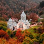
In the rugged cliffs and canyons of the Ustyurt Plateau, many followers of Sufism found solitude. Hermits carved not only modest cells into the limestone but also entire mosques. Religious schools were housed in these rocky galleries, where unity with nature provided the ideal atmosphere for communion with God. Followers of Islam revere the rock mosques of Ustyurt as highly as the holy cities of Mecca and Medina.

In the western part of Kazakhstan, near the Boszhira valley, lies one of the most cherished underground religious monuments. Pilgrims come here to honor the memory of the philosopher and Sufi follower Shopan-Ata. His necropolis is surrounded by burials dating back to the 10th–14th centuries.
The sage arrived in this land from Turkestan in the 12th–13th centuries. The location was chosen intentionally: Shopan-Ata instructed his disciples to shoot an arrow, and where it landed, they were to preach. The journey to Mangystau was arduous, but Shopan-Ata endured, bringing Sufism to the local people.
The underground mosque has been under state protection since 1982. Authorities oversee its condition, with the last restoration completed in 2016. The mosque is located 210 km from Aktau and 60 km from the city of Zhanaozen.


Beket-Ata, also known as Beket Myrzagululy, was a warrior, philosopher, and scholar who studied mathematics, physics, and astronomy. One night, while resting at the tomb of Shopan-Ata, the sage appeared to him in a dream, urging him to share his knowledge with the people.
The Beket-Ata Mosque is nestled in a mountain gorge at a depth of 1,500 meters. The path to this sacred site is a test of spirit and willpower. Along the way, travelers encounter healing springs, each said to cure specific ailments.


In addition to its more explainable—albeit unusual—attractions, the Ustyurt Plateau is home to many enigmatic objects. Scientists from various disciplines have puzzled over some of these phenomena for years.
Stone Warriors
In 1983, geologists stumbled upon a “stone army” near the Beyte spring. These battle-ready statues, now almost destroyed, remain a mystery. Their origins and purpose are unclear. The theme of warfare also appears in other discoveries: cave walls adorned with depictions of weapons and warhorses.
UFOs
Unidentified flying objects and strange flashes of light are often reported over the plateau. Ufologists claim the lights emerge from beyond the horizon in bright beams, briefly illuminating the surroundings.
An intriguing fact: smaller expeditions of two or three people are more likely to witness these phenomena than larger groups. For this reason, researchers avoid traveling to the plateau in large numbers. Who knows? The secrets of the former Tethys seabed might be grander than we ever imagined.

The Torish Valley is strewn with perfectly round stones. The spheres range in size from 20 cm to 2.5 meters, but even the smallest ones are surprisingly heavy, as if made of cast iron.
Scientists suggest that the stones’ cores consist of compressed remains of marine creatures from the ancient Tethys Ocean, with layers of sand and clay forming their surfaces. Based on their composition, the spheres are estimated to be at least 200 million years old.
Another theory proposes that these formations are the result of earthquakes. Tectonic shifts caused rocks to melt and compress into spherical shapes.

In 1986, aerial surveys revealed mysterious symbols on the ground. Triangular patterns, stretching over 100 km between the villages of Beineu and Sai-Utes, resemble crescent moons. At the tips of these figures are arrows with long shafts ending in massive rings up to 10 meters in diameter.
Some of the symbols are less distinct, while others are overlaid with newer patterns. It’s possible that old structures deteriorated and were replaced. Scientists propose two main theories regarding the origins of these geoglyphs:
In the 1970s, Soviet geologists used the arid Ustyurt Plateau as a testing ground for creating circular reservoirs. These were intended to support agriculture and aid travelers.
The reservoirs were to be formed through underground nuclear explosions. The theory was that the blasts would collapse the cavity, sealing it with a vitrified layer to prevent radiation from escaping. However, during one of the three tests, rockfalls and environmental contamination occurred. Additionally, prolonged earthquakes were recorded near each test site for up to a month. The project was ultimately abandoned.
The best starting point for exploring the Ustyurt Plateau is the city of Aktau, located 300 km away—a four-hour drive. Alternatively, one can set out from the city of New Uzen (Novi Uzeyn), just 60 km from the plateau. Tourism is well-developed here: visitors can join organized tours or rent vehicles and navigate using coordinates.
Traveling alone across the salty lands is unsafe. In case of a car breakdown or other mishap, help may be unavailable. For those unfamiliar with the location of the Ustyurt Plateau, guided tours are recommended. These cover all key attractions, and guides share insights into the mysteries and nature of the Aral Sea region.